Bike & Hike Trail
Metro Parks, Serving Summit County
Trail Location
This trail runs from Bedford to Kent, Ohio (Cuyahoga, Summit, and Portage Counties)
Park at any of the Bike & Hike Trail parking lots. These include:
State Route 82, West of Holzhauer Road in Sagamore Hills.
Brandywine Falls, Brandywine Road near the Interstate 271 bridge, Northfield Center.
Boston Heights, Boston Mills Road at the eastern edge of Cuyahoga Valley National Park.
State Route 303, Just west of Route 8, Boston Heights.
Barlow Road, East of Route 8, Hudson.
Springdale Road, North of Graham Road, South of Steels Corners Road, Stow.
Silver Lake Town Hall, Kent Road between Route 91 and Route 8.
State Route 91 Lot, Between Monroe Falls Boulevard and North River Road in Monroe Falls.
Silver Springs Park and Campground, Stow Road, Stow.
Trail Summary
Length: 33 miles.
Duration: 8 hours.
Surface: Asphalt.
Type: hike or bike in and back on same trail or park cars at each end of a segment and hike from one car to the other.
Difficulty: Easy
Accessibility: The trail is handicap accessible.
Trail Description
The Bike & Hike Trail generally runs along an abandoned railroad corridor from north to south. Some sections are along roads, as well. A long stretch of the trail runs along the eastern edge of the Cuyahoga Valley National Park. The trail is purportedly one of the oldest rail-to-trail conversions in the country.
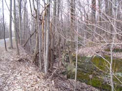
A portion of Boston Ledges along the Bike and Hike Path.
The MetroParks certainly chose a great rail corridor to convert to a trail. In the Boston Heights area, the trail traverses the lower side of the Boston Ledges. These rock outcroppings provide a cool, shaded environment that allows a great diversity of interesting plant life to thrive along the trail. You will see plants such as the Virginia Polypody, Bracken Fern, and Partridgeberry growing.
In the more open areas along the trail, such pioneer species such as Moth Mullein are more likely to be seen. You will also notice along the trail fast growing, light-loving trees such as Bigtooth Aspen.
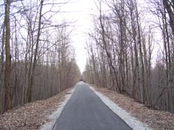
The paved Bike & Hike Trail in Summit County.
These are a sign that the area had probably been more open in the past and has only recently reverted to forest. Further away from the trail you can see species more typical of Ohio Forests, such as American Beech. Along the ledges, and in some deep ravines, you will also see stands of Eastern Hemlock. These hemlock stands are good habitat for the Ruffed Grouse.
The section of Bike & Hike Trail in Monroe Falls is along the Cuyahoga River. here you have the opportunity to see more bottomland or floodplain species, such as American Sycamore, and Green Ash. It is not uncommon to see a Great Blue Heron or two hunting or resting in this area.
Special Rules
Keep dogs on leash at all times. Be aware that the trail is used extensively by bicyclists, so stay to the right, and listen for audible signals such as bells to indicate you are being passed by a bicycle.
Nearby Trails
Boston Run trail
Buckeye Trail, Pine Lane to Boston Mills
Haskell Run trail
Ledges Trail