Holmes County Trail
Homes County Rails to Trails Coalition &
Holmes County Park District
Trail Location
Millersburg, Ohio (Holmes County)
Traversing Holmes County from Northeast to southeast, access to the trail can be gained At the Millersburg Depot, near the corner of Grant and Clinton Streets (turn west on Clinton from State Route 241). Also in Millersburg, the trail can be accessed from the Walmart parking lot on State Route 83 south of town. A third trailhead is located at Skip's Trail Depot, on State Route 83 in Holmesville.
Trail Summary
Length: 29 miles (12 miles open as of this writing)
Duration: varies, plan for 2 to 3 miles per hour, with more time if you want to look in depth at features along the trail.
Surface: Paved for much of the length, primitive earthen surface for the stretch from Millersburg to Killbuck.
Type: Multi-purpose
Difficulty: easy
Accessibility: Yes, generally. More primitive surfaced areas may create difficulties.
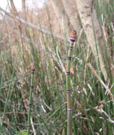
The horsetail, or Scouring Rush (Equisetum sp.) is an interesting plant that often grows on disturbed soils and near seeps. It is called Scouring Rush because its rough surface was used to scour pots and
pans before we had modern cleansers and steel wool.
Trail Description
The 29-mile long Holmes County Trail is a rails-to-trails project which utilizes the rights-of-ways of the old Cleveland and Pittsburgh Railroad in Holmes County. Through the efforts of the Holmes County Rails to Trails Coalition and the Holmes County Park District, this abandoned rail line is now a beautiful recreational trail through a variety of interesting habitats. In addition to serving the recreational and health needs of the county through promoting exercise and outdoor activity, the trail is a great way for tourists to see the beauty of the Holmes County countryside. The trail provides a safe alternative route for the county's Amish population, because it is open for buggy traffic, which helps avoid conflicts between the slow-moving horse-drawn vehicles and the fast moving traffic speeding along the main routes of the county. there aren't many trails out there that provide the opportunity to witness first-hand this remnant of living transportation history.
As you hike, bike, roller-blade, walk or ride your horse along this easy, flat trail in the heart of the largest Amish population in the world, you will enjoy wildflowers along the trail, as well as patches of forest, and views of rolling farmland in the distance. The trail is an excellent opportunity to enjoy the peaceful environment and slower pace of life in Holmes County.
Right off the bat, you will notice that the trail lies in, or near, a flat broad basin along Killbuck Creek. This flat area is the naturally occuring floodplain of Killbuck Creek. Rail lines were often built along stream corridors, because trains needed a fairly flat track, and costs were kept lower if railroad engineers selected routes that minimized the amount of digging and earth-moving required. Because of their historical choice to place the railroad in this stream corridor, you will have the chance to traverse floodplain and wetland complexes along a great length of this major creek, which was reputedly named for a Delaware Indian Chief of the area.
Along the Millersburg portion of the trail, you will walk through areas of disturbance, successional areas where nature is recovering from past human activity. Old fields and trail edges are shimmer in the fall with the yellow hues of goldenrod, mixed with the whites of a number of aster species. The fluffy seedheads of foxtail, a common grass that looks like, yes, a fox's tail, also lines short segments of the trail.
Where trees have been allowed to grow, you will see green and white ash, the white and green peeling bark of the American sycamore, and young wild black cherry. All of these are light-loving trees that grow well in areas that have plenty of sunlight. The bright environment along the trail also allows such delightful plants as red red raspberry to grow along the trail, so be careful not to snag yourself on their thorns as you walk by!
When you come to a lower lying area along the trail, where water collects and stands, take a close look and see if the shrubs growing in the water do not have little button-like balls growing near the tips of the branches. These bushes with buttons are known as buttonbush, believe it or not. There are a number of buttonbush swamps along the trail. While these shrub-filled wet spots may look like a waste of ground that could be put to productive use is drained, we humans have learned that sometimes, nature knows best.
Wetlands, like these buttonbush swamps, are not just homes to an incredible array of plants and animals. They also filter our water to keep it clean, hold excess water during and after rain storms, and help to recharge our groundwater resources. Over 90 percent of Ohio's original wetlands have already been destroyed through filling, draining, tiling, ditching and otherwise depriving them of water and removing their natural functions and values. The results are increased flooding, less groundwater, and less pure water. As you pass by these wetlands along the Holmes County Trail, think about how many gallons of water might be stored and filtered here for free. You might not be an engineer or an accountant, but it doesn't take too much thought to see that if we had to pay to create a system to hold our stormwater, clean it up, then re-discharge it slowly over time, it would be very costly, complicated, hard to maintain, and would never work as well as natures own filters, the wetlands.
Enjoy your walk along these beautiful wetlands and Killbuck Creek. If you have time, after you refresh your soul with some blissful walking in nature, visit the many attractions that Holmes County has to offer.