Chuckery Trail
Cascade Valley MetroParkMetro Parks, Serving Summit County
Location
Akron, Ohio (Summit County)
Park at the parking lot in the Chuckery area of Cascade Valley MetroPark, off Cuyahoga Street in Akron.
Summary
Length:2.4 miles.
Duration: 1 hour.
Surface: natural.
Type: Loop.
Difficulty: Easy.
Accessibility: No. (stairs)
Description
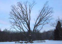
The Signal Tree in Cascade Valley Metro Park
Starting at the parking lot nearest the signal tree, walk west past the signal tree to the woodline. From this point, hikers may choose to follow the trail clockwise or counterclockwise. Heading clockwise on the branch of the trail to the north, you will hike though a floodplain forest composed of typical riparian trees such as sycamore (Platanus occidentalis), cottonwood (Populus deltoides), an occasional silver maple (Acer saccharinum), box elder (Acer negundo), and an occasional oak (Quercus spp). As you hike through this forest, you will see that much of the understory is composed of invasive shrubs such as Japanese multiflora rose (Rosa multiflora) and bush honeysuckles (Lonicera spp.) This is most likely due to the disturbance regime in floodplains. An occasional flood will come through, carrying away leaf litter, vegetation and light seeds from the area, opening the soil up for invasions from new plants which may spring up from seeds dropped by birds, or seeds brought in by the floodwaters themselves. These invasive plants crowd out native shrubs and wildflowers. In this setting, if the invasive shrubs were not present you would expect to find arrow-wood (Viburnum spp.), dogwoods (Cornus spp.), gooseberries (Ribes spp.), and alders (alder spp.).
While the shrub community in this forest is vastly altered due to invasive plants, fortunately the spring wildflowers largely reflect the vibrant diversity expected. Garlic mustard (Alliaria petiolata), an invasive herb brought to this country by europeans, does grow here, but has not yet had a major impact. Large patches of bloodroot (Sanguinaria canadensis), white-flowered trillium (Trilium grandiflorum), yellow trout lilly (Erythronium americana) and spring beauties (Claytonia virginiana) enliven the forest in ther spring. I hiked this trail most recently in winter, so the wildflowers were blanketted with a coat of barely disturbed snow.
Signs of animals abound along the trail. Deer tracks are frequent, an occasional squirrel chatters in the distance. songbirds flit to and fro, seeming to follow hikers though the woods. At may points, you will see signs of woodpeckers as well. In the picture to the left, notice the large oblong hole carved in the trunk of a dead cherry tree. This shape of hole in the location that it is in provides evidence of another animal that frequents this forest. The pileated woodpecker typically makes these marks on the lower portion of dead trees in its search for food.
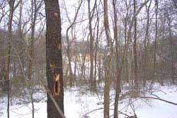
This wild black cherry tree shows signs of pileated woodpeckers.
As you continue, the river bends to the east, and the trail follows. Soon you will cross through a grove of oaks with the understoy cleared to make way for a pleasant picnic area on the banks of the Cuyahoga River. The trail continues through this grove and across a service road. Soon after this road, the trail follows old stone stairs up to intersect with the highbridge trail for a brief distance. As you follow the trail, it will begin to parallel a powerline and head generally south to southeast.
An occasional view will present itself to the west as you hike. You can see all the way to the other side of the valley, and in the fall, it is a good spot to look at the distant changing leaves. Soon, the trail will descend to the floodplain again. It weaves through meadows and small patches of forest until arriving back at the signal tree once more. Near the point where the trail enters the field at the signal tree, just to the right you will see a small pocket of wetland. During the winter, remnants of blue vervain (Verbena hastata) and broad-leaved cat-tail (Typha latifolia) stick up trough the snow. It is not uncommon to see great blue heron foraging in this area. If you walk into the wetland, you may just see one of these huge birds take to the air almost within reach.
Special Rules
Cascade Valley is open until 11 p.m. Dogs are not allowed on the sports fields.
Nearby Trails
Highbridge Trail, Cascade Valley and Gorge (Metroparks, Serving Summit County)
Oxbow Trail, Cascade Valley (Metroparks, Serving Summit County)
Schumaker Valley Trail, Cascade Valley (Metroparks, Serving Summit County)
Glens Trail, Gorge (Metroparks, Serving Summit County)
Gorge Trail, Gorge (Metroparks, Serving Summit County)