Butternut Loop Trail
Ohio Department of Natural ResourcesMalabar Farm State Park
Trail Location
Lucas, Ohio (Richland County, near Mansfield)
Malabar Farm State Park is located off State Route 603. From 603, head east on Pleasant Valley Road. About a mile later, turn left on to Bromfield Road. Pass the park entrance on your right. Continue past several farm buildings at the working farm area of Malabar Farm. On a nearly 90-degree curve, a dirt driveway will split off to the left. Follow this driveway to the end. Park at the Pugh Cabin Parking Lot.
Trail Summary
Length: 1 mile
Duration: 1 hour
Surface: natural, rocky and uneven
Type: hiking loop
Difficulty: moderate
Accessibility: No. The natural terrain is rough, rocky and uneven.
Trail Description
This rustic walking trail meanders through a well-developed forest of the beech-maple variety. The overstory is punctuated with small stands of wild black cherry, red Oak, and of course, the butternut trees for which the trail is named.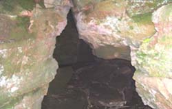
This is the first (lower) entrance to a cave along the Butternut Loop Trail.
The forest floor is teeming with life. Chipmunks and fox squirrels are a common sight for the quiet naturalist in this woods. In a short walk in the beautiful forest along this trail, the nature lover in you may count as many as three dozen distinct species of herbaceous plants. Small patches of blue cohosh provide forage for deer, while its blue berries provide tasty morsels for our avian friends that pass through. Above the groundcover, a fair covering of low shade, such as maple saplings, gooseberry, and other shrubs provide niches for many species of wildlife. Above the shrub and sapling layer, the forest has a midlevel of pole-sized trees waiting in the wings for a canopy tree to die. When that happens, the smaller trees will spring into rapid growth, filling the hole in the canopy. This is a well-functioning forest, with all the right components present in its structure.
Downed trees provide great habitat for insects, which in turn attract the amazing pileated woodpecker to the area. Soon, after walking up a slight grade, the trail takes us to an area rock outcroppings. A small stream appears to start at the base of a sandstone formation. Stepping into the slight depression, in the summer or fall, a cool breeze is likely to refresh you. To the right from the trail, a chasm leads to a small cave. It is possible, but perhaps treacherous to climb up a five foot height difference and then scamper up a steep trail out of the other side of the cave. It would be more prudent to look at the cave, then return to the trail and peer down into the cave from the top.
Above the cave, the forest seems to be younger, and the ground less rocky. It may be that this woods was cut for timber in past times, then allowed to return to forest without having been plowed. However, the wildflower diversity is still high. Generally, if an area is used for agricultural production, then reverts to a forest, the wildflower diversity does not spring back as quickly.
The return trip to the car is largely down hill. You may pass patches of white snakeroot, Solomon's seal, black cohosh, and at least six species of ferns. Take it slowly, and spend a little time trying to figure out how the forest developed in the way it did, and why the plants are growing in the way they do. Think about light conditions, soil moisture, competition with other plants, and perhaps animals as well.
Enjoy the hike!
Nearby Trails
Pleasant Valley Bridle TrailDoris Duke Woods Trail
Junglebrook Trail
Beginning, intermediate and advanced Skiing Trails